NYZ080
There are no active watches, warnings or advisories
| West Islip Weather | |||
|---|---|---|---|
| LAST READING AT TIME: 5:55 AM DATE: July 04 2024, time of next update: 6:00 am | |||
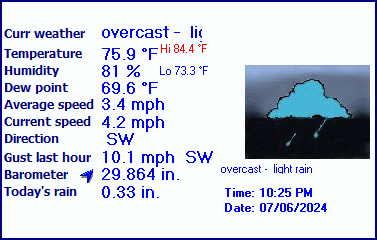
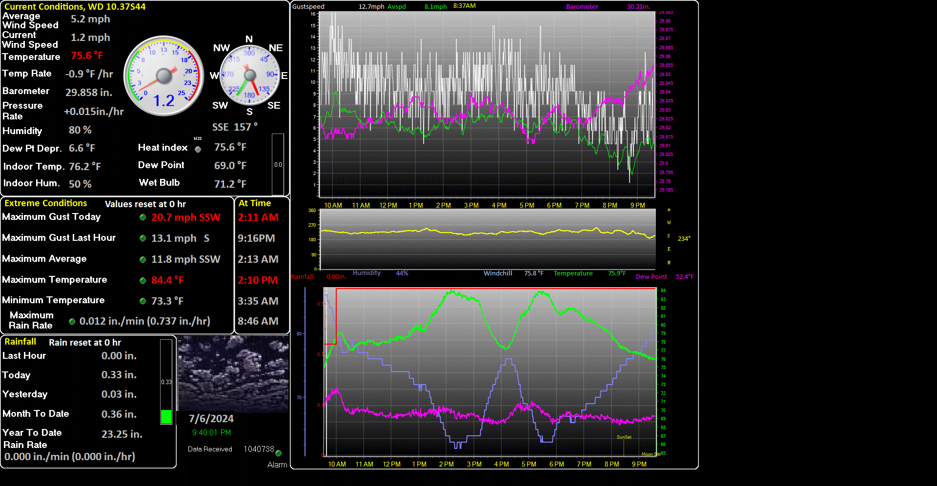
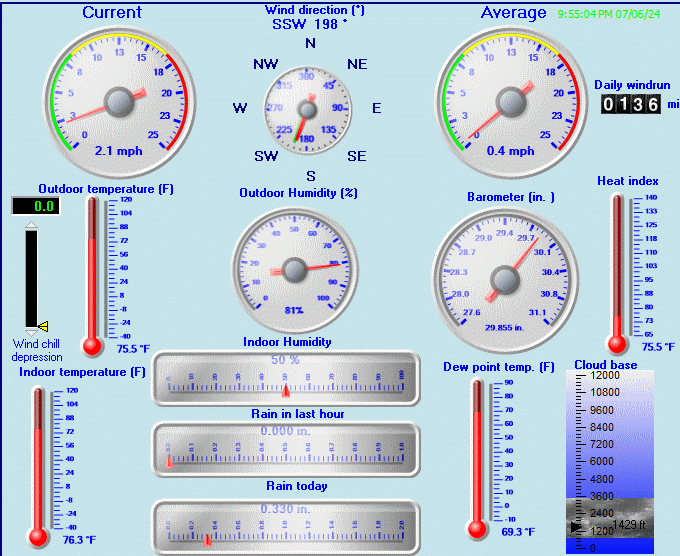
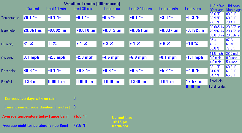
| Current Weather | mostly cloudy | Current Temperature | 69.1°F (20.6°C) (Heat Index 69.8°F ), Apparent temp 70.1°F |
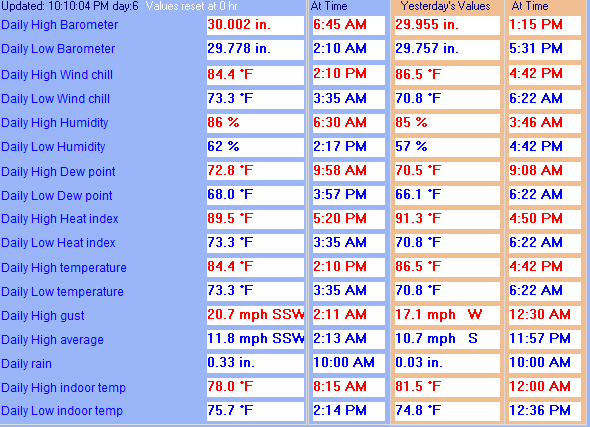
| Maximum Temperature (since midnight) | 70.4°F at: 12:03 AM | Minimum Temperature (since midnight) | 67.7°F at: 4:12 AM |
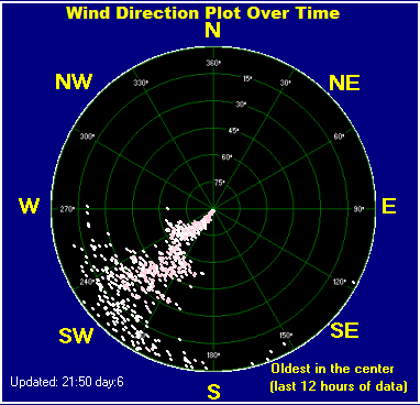
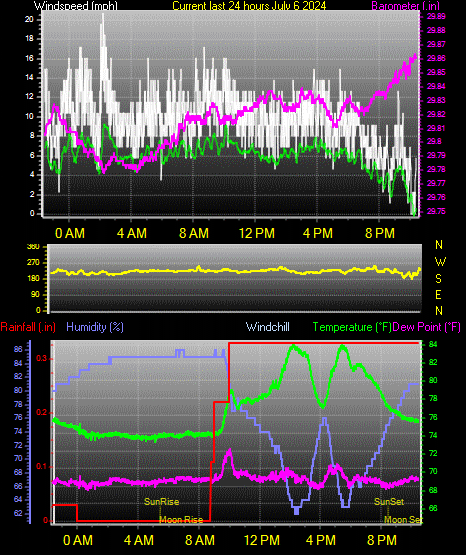
| Average windspeed (ten minute) | 4.6 mph | Wind Direction (ten minute) | SW (219°) |
| Heat Index | 69.8°F | Maximum Gust (last hour) | 11.5 mph at: 5:06AM |
| Maximum Gust (since midnight) | 16.8 mph at: 12:30 AM | Maximum 1 minute average (since midnight) | 8.1 mph at: 5:15 AM |
| Rainfall (last hour) | 0.00 in. (0.0 mm) | Rainfall (since midnight) | 0.00 in. (0.0 mm) --- |
| Rainfall This month | 0.00 in. (0.0 mm) | Rainfall To date this year | 22.89 in. (581.4 mm) |
| Maximum rain per minute (last hour) | 0.00 in/min | Maximum rain per hour (last 6 hours) | 0.00 in/hour |
| Yesterdays rainfall | 0.00 in | DewPoint | 62.3°F (Wet Bulb :64.7°F ) |
| Humidity | 81 %, Humidex 78.4°F | Barometer corrected to msl | 29.982 in. (1015.3 hPa) |
| Pressure change | -0.01 in. (last hour) | Trend (last hour) | STEADY |
| Pressure change (last 12 hours) | -0.12 in | Pressure change (last 6 hours) | -0.06 in |
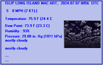
Expires:202407041500;;415923
FPUS51 KOKX 040755
ZFPOKX
FPUS51 KOKX 040754
ZFPOKX

Zone Forecast Product
National Weather Service New York NY
354 AM EDT Thu Jul 4 2024


NYZ080-041500-
Southwest Suffolk-
354 AM EDT Thu Jul 4 2024

.TODAY...Partly sunny. Highs in the upper 70s. Southwest winds
10 to 15 mph with gusts up to 25 mph.
.TONIGHT...Mostly cloudy with a chance of showers with a slight
chance of thunderstorms. Patchy fog after midnight. Some
thunderstorms may produce heavy rainfall. Humid with lows in the
upper 60s. South winds 10 to 15 mph. Gusts up to 25 mph in the
evening. Chance of rain 50 percent.
.FRIDAY...Patchy fog in the morning. Mostly cloudy with a chance
of showers in the morning, then partly sunny with a slight chance
of showers in the afternoon. Humid with highs around 80. South
winds 10 to 15 mph. Gusts up to 25 mph in the afternoon. Chance
of rain 50 percent.
.FRIDAY NIGHT...Mostly cloudy. A slight chance of showers and
thunderstorms in the evening, then showers likely with a slight
chance of thunderstorms after midnight. Some thunderstorms may
produce heavy rainfall. Humid with lows around 70. South winds
10 to 15 mph with gusts up to 25 mph. Chance of rain 60 percent.
.SATURDAY...Showers likely with a slight chance of thunderstorms
in the morning, then partly sunny with a chance of showers and
thunderstorms in the afternoon. Some thunderstorms may produce
heavy rainfall, then some thunderstorms may produce gusty winds
and heavy rainfall in the afternoon. Humid with highs around 80.
South winds 15 to 20 mph with gusts up to 30 mph. Chance of rain
60 percent.
.SATURDAY NIGHT...Mostly cloudy. A chance of showers and
thunderstorms in the evening, then a chance of showers after
midnight. Some thunderstorms may produce gusty winds and heavy
rainfall in the evening. Lows around 70. Chance of rain
50 percent.
.SUNDAY...Partly sunny. A chance of showers in the morning. Highs
in the mid 80s. Chance of rain 30 percent.
.SUNDAY NIGHT...Partly cloudy. Lows in the upper 60s.
.MONDAY...Mostly sunny. Highs in the mid 80s.
.MONDAY NIGHT...Partly cloudy. Lows in the upper 60s.
.TUESDAY...Partly sunny. Highs in the lower 80s.
.TUESDAY NIGHT...Mostly cloudy with a chance of showers. Lows
around 70. Chance of rain 40 percent.
.WEDNESDAY...Mostly cloudy in the morning, then becoming partly
sunny. A chance of showers. Highs in the lower 80s. Chance of
rain 40 percent.

$$


ISLIP LONG ISLAND MAC ART, NY, United States (KISP) 40-48N 073-06W 43M
Jul 04, 2024 - 04:56 AM EDT / 2024.07.04 0856 UTC
Wind: from the SSW (210 degrees) at 8 MPH (7 KT):0
Visibility: 10 mile(s):0
Sky conditions: mostly cloudy
Temperature: 69.1 F (20.6 C)
Dew Point: 64.0 F (17.8 C)
Relative Humidity: 83%
Pressure (altimeter): 30.04 in. Hg (1017 hPa)
Pressure tendency: 0.03 inches (0.9 hPa) lower than three hours ago
ob: KISP 040856Z AUTO 21007KT 10SM BKN070 21/18 A3004 RMK AO2 SLP170 T02060178 56009
cycle: 9
Use the RELOAD facility on your browser to retrieve the latest data.